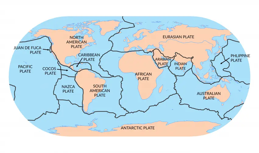
Papua New Guinea (PNG) is one of the most geologically active regions in the world. This beautiful island country sits on the Pacific Ring of Fire, a hotbed of seismic and volcanic activity. In 2024, PNG continues to be influenced by several tectonic plates, which cause frequent earthquakes, volcanic eruptions, and other geological phenomena.
What are Tectonic Plates?
Tectonic plates are large slabs of the Earth’s crust that float on the molten layer beneath, called the mantle. These plates are constantly moving, albeit very slowly, and their interactions at boundaries can cause significant geological events like earthquakes, volcanic eruptions, and the formation of mountain ranges.
Papua New Guinea and Its Unique Geographical Position
Papua New Guinea’s position on the western edge of the Pacific Ocean places it at the meeting point of several major and minor tectonic plates. These plate interactions make PNG one of the most geologically dynamic areas in the world. In 2024, the country remains vulnerable to seismic activity due to its location on the Pacific Ring of Fire.
The Main Tectonic Plates Around PNG
Several tectonic plates influence Papua New Guinea’s geology, contributing to its frequent geological disturbances. Below are the key tectonic plates impacting the region in 2024:
4.1 The Australian Plate
The Australian Plate is one of the major tectonic plates that PNG sits upon. It moves northward, colliding with the Pacific Plate and other smaller plates, which causes the subduction of the oceanic crust beneath the island.
4.2 The Pacific Plate
The Pacific Plate, which is the largest of all tectonic plates, plays a significant role in the region. It moves westward and meets the Australian Plate, causing high seismic activity in PNG.
4.3 The Caroline Plate
Though smaller in size, the Caroline Plate affects the northeastern part of PNG. Its movement also influences local geological activity, contributing to earthquakes and volcanic eruptions.
4.4 The Bismarck Plate
This smaller, local plate plays a crucial role in PNG’s tectonic dynamics. The Bismarck Plate is located to the northeast of the mainland and is actively interacting with both the Pacific and Australian Plates, contributing to the region’s geological complexity.
4.5 The Solomon Sea Plate
The Solomon Sea Plate is another small but significant plate that interacts with PNG’s tectonic environment. This plate’s movement influences both seismic and volcanic activity in the region, especially in the southern part of PNG.
Plate Boundaries and Their Impact
The boundaries where these plates meet are zones of intense geological activity. Convergent boundaries, where one plate moves under another, are particularly significant in PNG. These boundaries are responsible for the high frequency of earthquakes and volcanic eruptions in the region.
The Ring of Fire and PNG’s Volcanic Activity
Papua New Guinea is part of the Pacific Ring of Fire, a horseshoe-shaped region where most of the world’s volcanoes and earthquakes occur. The Ring of Fire is formed by the boundaries of several tectonic plates, and PNG, sitting at the intersection of many of these plates, experiences frequent volcanic activity as a result.
How Do These Plates Affect PNG in 2024?
7.1 Earthquakes in PNG
The movement of the tectonic plates beneath PNG leads to frequent earthquakes. These earthquakes can range from minor tremors to major, destructive events. In 2024, PNG continues to experience seismic activity as the plates shift and collide.
7.2 Volcanic Eruptions
PNG is home to several active volcanoes. The movement of tectonic plates beneath the surface causes magma to rise, leading to volcanic eruptions. In 2024, the risk of volcanic activity remains high due to the constant plate interactions.
7.3 Tsunami Risks
Because PNG is an island nation surrounded by tectonic activity, the region is also at risk of tsunamis. Underwater earthquakes caused by plate movement can generate massive waves that pose a serious threat to coastal communities.
Notable Earthquakes and Eruptions in Recent History
PNG has seen several significant earthquakes and volcanic eruptions over the years. The 2018 earthquake, which registered a magnitude of 7.5, is one example of the devastating power of tectonic activity in the region. Volcanic eruptions, like those from Mount Tavurvur, also highlight the ongoing risks.
Conclusion
Papua New Guinea, located at the crossroads of several tectonic plates, is a hotbed of geological activity in 2024. The Australian, Pacific, Bismarck, Solomon Sea, and Caroline Plates all play a role in shaping the region’s landscape and influencing the frequency of earthquakes, volcanic eruptions, and tsunamis. By understanding the dynamics of these plates and staying prepared, PNG can continue to manage the risks posed by its unique geological setting.
FAQs
- How many tectonic plates affect Papua New Guinea?
Papua New Guinea is influenced by five key tectonic plates: the Australian, Pacific, Bismarck, Caroline, and Solomon Sea Plates. - Why does PNG experience so many earthquakes?
PNG sits at the intersection of multiple tectonic plates, leading to frequent seismic activity. - What is the Pacific Ring of Fire?
The Pacific Ring of Fire is a region of high volcanic and seismic activity, where many tectonic plates meet. - How do tectonic plates cause volcanic eruptions?
When tectonic plates move, they can cause magma to rise to the surface, leading to volcanic eruptions. - Is PNG at risk of tsunamis?
Yes, due to its tectonic activity, underwater earthquakes in the region can generate tsunamis.

